Jarrahdale’s Future Update On the Jarrahdale Communications Tower ‘The Tower’
Brief Background
The Tower is owned by the Shire of Serpentine Jarrahdale(“the Shire”) and was built in 2001 using grant money provided by the Federal Government’s Networking the Nation Board. It stands on 2.25hectaresof land leased from the Department of Biodiversity, Conservation and Attractions(“DBCA”). The site islocated in State Forest just off Kingsbury Drive not far from the townsite of Jarrahdale.
The Tower was designed as a multipurpose structure and can accommodate up to 12 service providers. Currentservicesinclude a Telstra mobile base station, an Optus mobile base station, Shire Fire and Emergency radio equipment (also can be used by State Emergency Services, St Johns Ambulance),andWA Police radio equipment.(DBCA may still have radio equipment on the Tower).Service providers enter leaseswith the Shire and pay rental for space in the equipment shelters and on the Tower. This lease money in turn helps cover upkeep of the Tower and rental of the land leased from DBCA.
The Tower is held in place by about 21 wire cables which are anchored to the ground with large concrete blocks some of which are quite some distance away from the Tower. All of the 2.25 hectares of land is needed to accommodate this installation.

CoverageArea
The Tower is 120 metres tall so it covers most of Jarrahdale Locality 6124. (A description oftheJarrahdale Locality boundary is noted at the end of this report for those of you who want further details.)The coverage is reasonable,but there are black spots and mobile reception fades towards the boundaries of Jarrahdale locality. For example, coverage fades out at the Serpentine and Pipehead Dams and people living below the dams down to Selkirk Road use the Serpentine tower.
Because of the height of the Tower, an aircraft warning light must be attached to the top of the mast. This is a legal requirement under Commonwealth Civil Aviation Legislation.
The light also has to be maintained and monitored. If the light goes out the Shire must report the outage to the nearest Civil Aviation Safety Authority(“CASA”) office so that a warning can be sent to aircraft in the area of the Tower.
The warning light on the Tower is a red medium intensity flashing light that operates from dusk until dawn. It can be seen 50 kilometres away. (Amateur fishermen in Rockingham use it to navigate back to shore at night.)
There is a high-intensity white 24-hour day/night light available, but this light is not normally used in areas of bush or near where people live as it is very disruptive to native animal routines and interferes with people’s sleep.
Assessment of the Tower
In early 2020 Jarrahdale’s Future members began assessing essential infrastructure in Jarrahdaleto to determine if it was still robust enough and fit for purpose in today’s conditions. TheTower stood out as failing that test badly. After twenty years of service, the Tower was clearly in need of an upgrade. The increasing fire risk in the Jarrahdale area, the increasing amount of traffic in the area, the increasing number of people using the town and the surrounding forest for recreation, the increasing number of helicopter rescues and emergency evacuations,meant that Jarrahdale needed a much more resilient means of communication.
Four main problems needed to be addressed:
1. Power outages are not infrequent in Jarrahdale and can last for a day or more. Service providers on the Tower generally provided their own backup batteries. These rarely gave more than 2 to 3 hours backup power at the most,so when the batteries ran out all services on the Tower went down.
2. Regrowth vegetation was encroaching on the Tower and equipment shelters making it vulnerable in an intense bushfire, particularly to radiant heat.
3. The aircraft warning light was not working and had not been working for some time.
4. Monitoring of the Tower for faults and breakdowns was difficult due to the area being quite isolated.
Work on the Tower
Jarrahdale’s Future members had discussions and communications with a wide range of relevant parties including the Commonwealth Department of Communications, the State Department of Primary Industry and Regional Development, the Jarrahdale DBCA division, the Shire, the Jarrahdale community, and many individuals with knowledge of the issues involved.
The result was that the Shire through their Fire and Emergency Services Department decided to take on the task of upgrading the Tower.
As a result of all the consultationsJarrahdale’s Future had with interested parties it became clear that any backup power to the Tower had to be sustainable for at least 4 days. The Shire has now installed a diesel fuel generator with a 4-day fuel supply. All the service providers on the Tower are connected to this backup power and the generator turns on automatically if there is a power outage.
After the initial failure when the generator did not automatically fire up after an outage late last year (due to a dud battery), the Shire purchased and installed a monitoring device at the generator. An accompanying App has been loaded onto the mobile phone of a Senior Shire Officer. The device will detect any problem with the generator, and an automatic message will go to the Officer for prompt action.
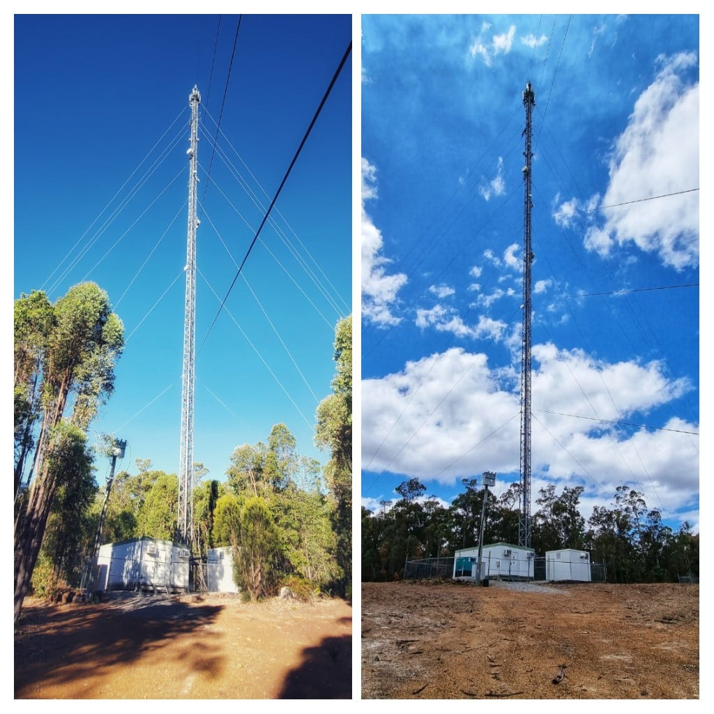
A successful Shire application was made through the Department of Fire and Emergency Services Mitigation ActivityFundingfor monies to undertake the necessary clearing of vegetation around the Tower. Consultations were held between the Shire and the local division of DBCAto agree on the fire mitigation plan. The DBCA also agreed to increase fire mitigation around the area. This work was completed by the end of last year. (See before and after photographs below.)This considerably decreases the likelihood of the Tower being damaged in a major fire event.
The aircraft warning light has been replaced. Monitoring this light has been a problem in the past. Telstra have agreed to install a monitoring device on the light that will send a signal to Telstra if the light fails. This signal will be forwarded to the CASA office at the Perth Airport and to the Shire, so the appropriate action can be taken. A Telstra team have visited the site and the Shire is currently awaiting confirmation that the monitoring device has been installed.
The Shire have also made the monitoring and upkeep of the Tower an item in the job description of the Coordinator Emergency Services. Corporate knowledge is easily lost when people move in and out of jobs very frequently, as seems to be normal these days. This should ensure that the Tower will not ‘fall off the agenda’ in future.
Community monitoring
Just as people move in and out of jobs more often than in the past so do people who move in and out of homes frequently. People also move to Jarrahdalefrom the Perth suburbs and think that essential services are the same as they were in the suburbs. But Jarrahdale is a country town and in-country towns, things are not always as they seem! So how do we keep the community informed on an ongoing basis about issues like the Tower? It has been agreed that the JCC will call for an annual report on the Tower from the Shire and the Jarrahdale’s Future subcommittee. This will be stored in the JCC files and loaded onto Facebook so residents gain an understanding of the essential infrastructure in Jarrahdale.
This document is the first such report.
Note: Description of Jarrahdale Locality 6124 boundary
Starting at Kinsella Road on Albany Highway the boundary runs south on the western side of the Highway to a point south of Sullivan’sRock and then heads southwest to meet the Serpentine River. The boundary then runs west alongside the northern edge of the Serpentine River, the Serpentine Dam and the Serpentine Pipehead Dam, then along the southern boundary of the Millbrook estate. It then heads southwest to SelkirkRoad on the South West Highway. The boundary then runs north on the eastern side of the South West Highway to a point between the old Alcoa Railway Bridge and Kiernan Road and then winds its way northeast to Kinsella Road crossing Nettleton Road near Alcoa Road.
